The aim of this project is to understand the hydrogeological water system of the region and its interaction with the Mediterranean Sea and surrounding aquifers. The future climatic changes will also be considered since they will create additional stresses on the water resource.
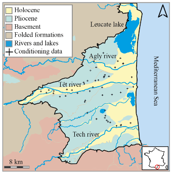 Figure 1: Study zone (Dall'Alba et al. 2020)
The first step is the construction of 3D geological and lithological models of the aquifer. One of the main parts of this project is to focus on the geostatistical modelling of the Continental Pliocene layer, which is described as heterogeneous, complex and represents one of the main water resources of the system. Different advanced geostatistical tools will be used to model this layer - Sequential indicator simulations, object-based models, Pluri-gaussian simulations and Multiple-point statistics simulations.
The novelties of this project are the integration of the offshore part of the aquifer system, the use of 3D auxiliary variables to describe the non-stationarity of the spatial distribution of the simulated facies and the test and integration of unstructured grids into the geostatistical simulations.
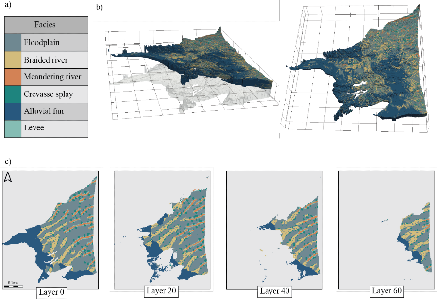
Figure 2: Geostatistical simulation of the Continental Pliocene aquifer. a) Simulated facies. b) 3D view of the on-shore Pliocene. c) 2D horizontal cross-sections (Dall’Alba et al. 2020)
These models will create an ensemble, which will characterize the uncertainty regarding the spatial distribution of the sedimentary facies. Since few hard-geological data are available for this aquifer in comparison to its extent, integrating different approaches, each with their own benefits and own drawbacks, ensure to maximize the integration of the geological data and the general conceptual knowledge of the aquifer into the modelling approach.
The next step of the project will consist in the transfer of these lithological models towards physical properties (permeability, porosity and storage) that are essential input parameters for the hydrodynamic simulations. Each of the previously created geological model will lead to a hydrodynamic model in an automatic way.
Finally, after calibration of these models, several climatic scenarios will be applied, in order to provide information about the future climate change and water uses impact on groundwater and the associated uncertainties.
Key words: Geostatistical modelling, hydrodynamic modelling, coastal aquifer, climate change.