However, the availability of in situ gauge stations has been steadily declining worldwide, imposing a need for alternative techniques. Globally available remote sensing data on river width and elevation can be used in data assimilation hydraulic models to estimate the discharge in ungauged basins. The accuracy of these models depends on information about the river’s bathymetry, which is rarely available. In this context, the Ph.D. suggests a novel approach to estimating river bathymetry. Initially, width and elevation data from existing and past satellite missions will be used. River width data will be produced from optical reflectances (e.g. Sentinel 2) and radar backscatters (e.g. Sentinel 1) using the SurfWater processing chain. River water elevation will be exploited from altimetry databases (e.g. HydroWeb). Since the spatiotemporal resolution of the sensors varies, different interpolation approaches will be tested in combination with hydraulic models to account for the propagation of the dynamics. The time series of width and height will allow an estimation of the observed part of the bathymetry (dry bathymetry). While the distribution of the elevations under the lowest observed water level (wet bathymetry) cannot be measured directly and will be approximated using hydraulic model inversion algorithms combined with auxiliary discharge data obtained from global hydrological models. Subsequently, the model will be updated with data from the forthcoming Surface Water Ocean Topography (SWOT) satellite, the first one to provide concurrent measurements of width and elevation.
Keywords: SWOT, multi-satellites, Flood Plain, DEM, data assimilation, hydraulics
|
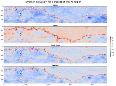
Figure 1: Errors in existing Digital Elevation Models DEMS (a) SRTM1 (b) MERIT2 (c) Copernicus3 and (d) FABDEM4 compared to Lidar data for a subset of the Po River (Italy).
|
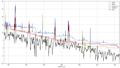
Figure 2: Comparison between elevations along a subset of the centerline of the Po River extracted from the Lidar data (black), SRTM (green), MERIT (blue), Copernicus (purple) and FABDEM (red)
|
REFERENCES :
1 Farr, T. G., & Kobrick, M. (2000). Shuttle Radar Topography Mission produces a wealth of data. Eos, Transactions American Geophysical Union, 81(48), 583-585.
2 Yamazaki, D., Ikeshima, D., Neal, J. C., O'Loughlin, F., Sampson, C. C., Kanae, S., & Bates, P. D. (2017, December). MERIT DEM: A new high-accuracy global digital elevation model and its merit to global hydrodynamic modeling. In AGU fall meeting abstracts (Vol. 2017, pp. H12C-04).
3 The European Space Agency (n.d.). Copernicus DEM - Global and European Digital Elevation Model. https://doi.org/10.5270/ESA-c5d3d65
4 Hawker, L., Uhe, P., Paulo, L., Sosa, J., Savage, J., Sampson, C., & Neal, J. (2022). A 30 m global map of elevation with forests and buildings removed. Environmental Research Letters, 17(2), 024016.